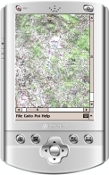
MAPLORER is a free ‘moving map’ navigation program for Windows CE and Windows Mobile based portable devices such as GPS systems, PDAs and smartphones.
You can use MAPLORER with maps captured as JPG images. It organizes the maps in tiles, allows you to navigate through them and add Poi's (points of interest). Map coordinates can be added using a POS text file. MAPLORER can then display your current position, load and log tracks, etc.
Installation
- Unzip the ZIP archive to an empty folder on your PC.
- Edit the file Gps.ini to adapt the settings of your GPS. If you don’t know the settings, check the manual or google for your GPS’ make and model.
- If you don’t have a GPS receiver, use ‘Fake=1’ to use the map browser only.
- Just copy the entire directory (including the modified gps.ini) to your device
- Start maplorer.exe (no installation required).
Next  Making maps